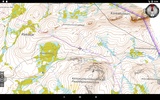
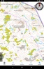
Jahtikartta outdoor GPS map application is designed to enhance your outdoor adventures across Finland, Sweden, and Norway by providing comprehensive terrain maps and location services. Equipped to navigate terrains without the need for active internet access, this app allows you to download maps beforehand, ensuring seamless guidance while you explore remote areas.
Key features include real-time GPS location tracking, a speedometer, and a compass that offers both direction and distance to your intended destination, all available at your fingertips. You can also save specific waypoints to revisit or mark important spots. Moreover, the app enables you to draw and measure routes and areas efficiently, enhancing your outdoor planning and navigation experience.
For users engaging in property-related activities or requiring more detailed geographic information, the Pro subscription offers additional functionalities. This includes detailed property boundaries, enhanced map loading options, and searches for coordinates using place names or addresses. Pro users also benefit from access to hunting area boundaries, team location sharing, and GPRS positioning for compatible GPS locators.
Optimized for outdoor enthusiasts who demand precision and reliability, the app stands out as a resourceful tool, ensuring that your wilderness explorations are safe and well-informed.
Requirements (Latest version)
- Android 7.0 or higher required
Comments
There are no opinions about Jahtikartta outdoor GPS map yet. Be the first! Comment